New Mexico, Colorado, Arizona & Utah - October 7 - 18, 2019
|
The North Rim of the Grand Canyon and Monument Valley have been on our bucket list for some time and we decided that by October, it had cooled down enough from the intense summer heat that is common in that area. We had been to Southern Utah a few years back and thoroughly enjoyed it, and we decided that there was more to see in Northern Arizona and Southern Utah. We were not disappointed. We hope that you enjoy our story and photos. It was very difficult to cull down over 800 photos to about 100 that would fit into our space. There was just too much beautiful scenery. |
|
[Monday] October 7 This morning we left home at 8:00 am and took the Westpark Tollway to the Beltway 8 to Bush Intercontinental Airport. We flew United Express (operated by Mesa Airlines) to Albuquerque. Our Embraer 175 departed at 12:08 pm. It was a smooth ride. We got our rental car from Hertz and took l-25, US-285 north to Alamosa, CO. We arrived at our Holiday Inn Express in Alamosa at about 7:15 pm - just after sunset. It was a nice drive through a wide valley between two rolling mountain ranges. We saw lots of signs for Elk Crossings, but never saw any Elk. [Tuesday] It was 26 degrees in Alamosa this morning. After breakfast, we met with our lawyer to take care of some business in Alamosa. We drove around town and saw lots of deer in peoples yards. After lunch in town, we drove to Durango, CO. The leaves along the road were beautiful, with full fall foliage. On the road to Durango, we went over the 10,856-foot Wolf Creek Pass on US-160. Wolf Creek Pass is on the Continental Divide.
After we checked into our hotel, we watched the Durango and Silverton steam trains (there were 3) arrive at the station. We walked around the Main Street area. The temperature today was in the 60's and low 70's.
[Wednesday] Today after breakfast in the hotel, we departed from Durango on US-160 and AZ-98 to Page. On the way, we went by the monument to the Four Corners of the states of Utah, Arizona, Colorado & New Mexico and stood on the exact point where they meet. When we arrived in Page, AZ, we checked into the Courtyard by Marriott hotel.
We arrived in mid-afternoon and booked a tour for Friday morning at 10:20 for Antelope Canyon-X. We then drove over to the Glen Canyon Dam and took photos of the dam, Lake Powell and the Colorado River Bridge just before sunset.
[Thursday] Early today we drove the 2 1/2 hours from Page to the North Rim of the Grand Canyon National Park. We spent the entire day at the park at the various viewing sites. On the way into the park we saw the herd of buffalo in the field beside the road.
At the lodge, we walked along the rim trail to Bright Angel Point to one of the best viewing points at this location.
We ate lunch in the lodge and drove to each of the viewing points along the north rim.
The drive through the park was spectacular. The Aspens were in their full fall colors. We saw deer and turkey.
The North Rim of the Grand Canyon was to close the next week (mid-October), so we were getting in late in the season. The temperature was in the 30's and low 40's all today at the park. We stopped at the Point Imperial, Point Imperial is the highest rim overlook in the park at elevation 8,803 feet. From here the canyon view encompasses Mt. Hayden, Vermilion Cliffs and Marble Canyon as well as an area of the park that was burned by the 2000 Outlet wildfire.
We then drove to Vista Encantada, Roosevelt Point, Walhalla Overlook and Cape Royal to see the view of the canyon from each one.
We didn't get back to the hotel until 8:30 pm. [Friday] This morning after breakfast in our hotel, we drove south on AZ-98 about 10 miles for our tour of Antelope Canyon-X. It is a guided tour of two slot canyons given by Navajo guides. It lasted 1 1/2 hours and went into deep canyons with spectacular colors.
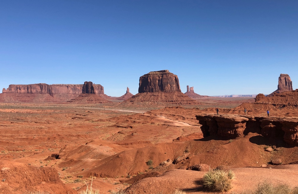
This afternoon we drove up US-163 to Mexican Hat, UT. The road from the south goes through the iconic Monument Valley and we stopped a lot for photos.
[Saturday] Today was a very busy day, but worth every minute. This morning we drove south of Mexican Hat to the Monument Valley scenic drive that is operated by the Navajo Nation. It was a 17 mile dirt road through some of the most impressive rock formations. You get very close to them.
We ate lunch at The View Restaurant at the Visitor Center. We then drove back north of Mexican Hat to Gooseneck State Park to view the famous switchbacks on the San Juan River. I doubt if there is anything else like it in this country, and perhaps the world.
After we finished up at Gooseneck State Park, we drove a little further north to Valley of the Gods. We then drove a 17 mile dirt road through another spectacular display.
On the way back to our hotel, we saw more interesting mountain formations and including the one that gave Mexican Hat it's name.
God really outdid Himself when he made southern Utah. [Sunday] This morning we left Mexican Hat and drove north to Moab, UT. On the way, we took a side trip to The Needles Overlook at Canyonlands National Park. This is another amazing view of the large canyon carved in the rock by the Colorado River on its way further southwest to the Grand Canyon. We stayed in Moab until Thursday.
[Monday] Today we went to Arches National Park, which is one mile north of Moab, and drove to about half of the viewing points in about 3 hours. At each point we walked on the trails that go to each arch. We decided to come back another day and finish the rest of the park.
In the afternoon, we drove the LaSal Mountain Loop Road. This beautiful drive started by going beside the Colorado River, before it started into the La Sal Mountains. It was about a 50 mile loop, but well worth the drive.
[Tuesday] Today we drove into Canyonlands National Park, The Island in the Sky section, to Grand View Point Overlook. We walked along the edge of the rim for 1 mile to the best view in the canyon. This is the area where the Green River joins the Colorado River. The canyon is massive here with both rivers contributing to the view.
On the way back out of the park in the afternoon, we stopped at Green River Overlook, Buck Canyon Overlook, Shafer Canyon Overlook and the Visitor's Center on our way back to Moab. It was a full day again in the scenic area. The weather was perfect, with clear sky and temperature in the 50's and 60's all day.
[Wednesday] Today we drove to Arches National Park again and finished the visit we started two days ago. We began by driving to the end of the road to see Tunnel Arch and Pine Tree Arch. We then drove back to see Skyline Arch. Then we continued to Broken Arch and Sand Dune Arch. They say that there are over 2,000 arches in the park, but only a few are set up for tourists. We went by Fiery Furnace Viewpoint, Lower Delicate Arch Viewpoint and Panorama Point on our way back to the Visitors Center, where we saw a 15 minute video on the park.
We left the park about 3:30 pm and drove about 25 miles to Dead Horse Point State Park. This was to best view of the Colorado River from the rim of the canyon that we saw. This park is located adjacent to Canyonlands National Park. You can get the story of how it got it's name by asking Google.
We left the park about 5:30 pm and ate supper in Moab. [Thursday] Today we left Moab and drove back to Albuquerque. It was a 367 mile 9 hour drive through Utah, Colorado and New Mexico. We passed through about 5 different Native American reservations on the way. We spent the night at the Holiday Inn Hotel near the Albuquerque Airport. [Friday] We returned our car to the Hertz rental place at the airport and took our United flight UA6021 back to Houston. We arrived in Houston at about 5:30 pm.
This draws to a close our brief trip to New Mexico, Colorado, Arizona and Utah. We hope you enjoyed the photos and brief descriptions of our activities. God willing, join us again soon for another travel adventure. Adios for now, Lawson & Kay Oh come, let us sing to the Lord! Let us shout joyfully to the Rock of our salvation. Let us come before His presence with thanksgiving; Let us shout joyfully to Him with psalms. For the Lord is the great God, And the great King above all gods. In His hand are the deep places of the earth; The heights of the hills are His also. The sea is His, for He made it; And His hands formed the dry land. (Psalms 95:1-5 NKJV) |


